
Comparative analysis of computer vision techniques for deforestation detection using LANDSAT 7 satellite images
Article Sidebar
Main Article Content
Abstract
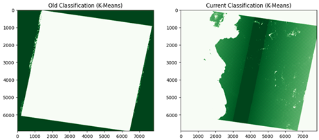
This study explores the application of computer vision techniques for deforestation detection using LANDSAT 7 satellite imagery. Two main classification algorithms, Random Forest and K-Means, were employed to evaluate their effectiveness in identifying deforested areas. Random Forest, a supervised learning method, demonstrated high accuracy and robustness due to its ability to handle labeled data and multiple variables, making it suitable for this task. On the other hand, K-Means, an unsupervised algorithm, struggled with accuracy in this context, highlighting its limitations when dealing with complex real-world data such as satellite imagery. The TOPSIS method was applied for a multi-criteria evaluation of the algorithms, providing a comprehensive comparison that revealed the superiority of Random Forest in this application. TOPSIS was instrumental in objectively assessing the performance of each algorithm based on several criteria, ensuring a balanced and thorough analysis. The study concludes that integrating high-resolution satellite data with sophisticated classification and assessment techniques such as Random Forest and TOPSIS significantly improves deforestation detection and monitoring, contributing to more effective forest conservation strategies.
Downloads
Article Details

This work is licensed under a Creative Commons Attribution 4.0 International License.